The masthead on this page shows a communication tower, looking up at the tower from the ground. The tower is covered with white frost, and a bright blue sky can be seen in the background.
About NOAA
The NOAA All-Hazards/Weather Radio is a service of the National Weather Service, National Oceanic and Atmospheric Administration (NOAA), and U.S. Department of Commerce, provided in cooperation with the Wisconsin Division of Emergency Management and through the facilities of the Wisconsin Educational Communications Board.
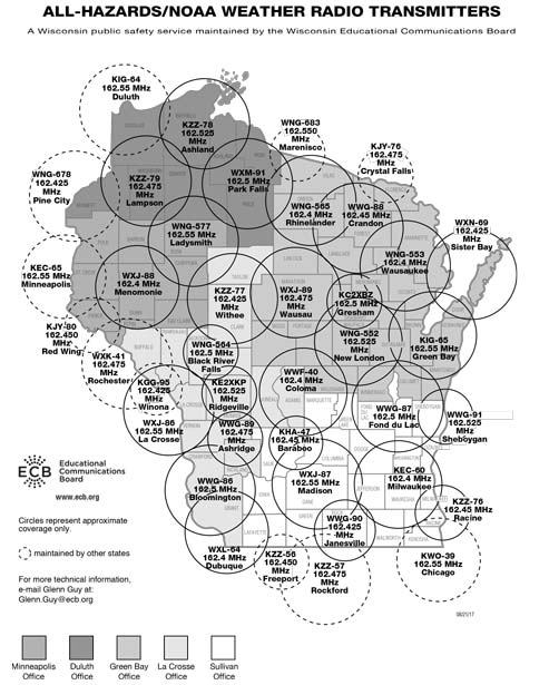
Weather Radio Stations
| City | Call Signal | Frequency |
| Ashland | KZZ-78 | 162.525 MHz |
| Ash Ridge | WWG-89 | 162.475 MHz |
| Baraboo | KHA-47 | 162.450 MHz |
| Black River Falls | WNG-564 | 162.500 MHz |
| Bloomington | WWG-86 | 162.500 MHz |
| Coloma | WWF-40 | 162.400 MHz |
| Crandon | WWG-88 | 162.450 MHz |
| Delafield / Milwaukee | KEC-60 | 162.400 MHz |
| Dubuque / Kieler | WXL-64 | 162.400 MHz |
| Eau Claire / Menomonie | WXJ-88 | 162.400 MHz |
| Fond du Lac | WWG-87 | 162.500 MHz |
| Green Bay | KIG-65 | 162.550 MHz |
| Gresham | KC2-XBZ | 162.500 MHz |
| Janesville | WWG-90 | 162.425 MHz |
| La Crosse | WXJ-86 | 162.550 MHz |
| Ladysmith | WNG-577 | 162.550 MHz |
| Madison | WXJ-87 | 162.550 MHz |
| New London | WNG-552 | 162.525 MHz |
| Park Falls | WXM-91 | 162.500 MHz |
| Racine | KZZ-76 | 162.450 MHz |
| Rhinelander | WNG-565 | 162.400 MHz |
| Ridgeville | KE2-XKP | 162.525 MHz |
| Sheboygan | WWG-91 | 162.525 MHz |
| Sister Bay | WXN-69 | 162.425 MHz |
| Spooner | KZZ-79 | 162.475 MHz |
| Wausau | WXJ-89 | 162.475 MHz |
| Wausaukee | WNG-553 | 162.400 MHz |
| Withee | KZZ-77 | 162.425 MHz |
Weather Radio Coverage

